I bought a video camera with several different brackets, including a handlebar mount. I'm going to use this instead of still photos to show the routes and points of interest. My first trial of the camera was from home to Zarcero. I didn't know that the microphone would pickup so much noise and I'll work on that and adding some narration too.
It's getting very rainy here, but I'll try to get some different routes done. There's no map or route slip for this. It's just a short part of the Palmira route posted previously.
http://www.youtube.com/watch?v=8VGMhy_p9F0

Sunday, July 7, 2013
Monday, June 17, 2013
The Path Less Traveled By
I've had some minor health problems and major laziness that has kept me from doing more than local, short rides. Looking at maps always gives me the itch and I have the bad habit of seeing bike routes everywhere I look. So I did try to put together a 3 day trip that didn't work as planned. You may still enjoy hearing about it.
When Marcia wanted to go to the Caribbean Coast with a bunch of Gringos, I saw it as an opportunity to do a little 3 day tour. I planned a loop from home to La Fortuna, a ride around Lake Arenal, and then a return via a different road to complete the loop.
I have driven most of these roads and thought I had a good feel for what I was facing. The first leg would be mostly downhill and measure about 80 km. The second leg, the lake loop, would be longer. I had missed one turn on my pre-flight drive and knew that the south shore road was unpaved, but I figured it wouldn't be a problem. My memory was that it was a fairly flat road. The return leg would be very scenic and would pass through a cloud forest. There would be significant climbing involved.
As the date approached, I started having second thoughts. I considered that I would be able to bail and hop a bus if the climb was too hard. But in the end I opted to drive to La Fortuna to bike the lake and then do a second day through some of the local towns.
It's a good thing I did. The day of my lake loop turned into a 21 mile out and back with 1250 ft of climbing and I didn't even make it to the lake. My memory of flat roads was way off. While not in the mountains, it seems like the road is constantly climbing and descending at some pretty challenging grades.
The next day I decided to drive the loop and check it out with my GPS. By the time I got to the end of the pavement on the south shore, had climbed 4732 ft and was only at an elevation of 1843 ft. The road wasn't bad, but got progressively worse until I needed my 4-wheel drive.
I reached a spot where I turned off the unpaved road onto an even worse trail and faced a wooden bridge and a decision. I held my breath and pressed on. Fortunately, that was the only one. All of the other water crossings didn't have bridges. There were 6 or 7 water crossings and I was glad it was the end of the dry season. The widest, deepest one was about knee deep. I didn't see another vehicle. I wonder why.
It would have been impossible for me to ride my bike on this “road” and even a mountain biker would have been walking parts of it. The loop measured 140 km, not a great distance. It involved 7583 ft of climbing.
photos
Thursday, December 27, 2012
I'm Still Here
It's been some time since I posted and I haven't been doing a lot of riding. I have driven the La Fortuna route to preview the ride. I was also out doing a slightly longer loop from home when I had one of my shift levers fall apart.
I could use that, the weather, the holidays, or any number of other excuses for not riding more. The truth is that I've been lazy. Today, I finally got on the bike and decided to post this short route just to show that I still have good intentions. This ride is short, but has 2800 ft of climbing. Most of the climbing is between Zarcero and Palmira and it's very scenic.

This is my latest bike. It's a steel Novara Randonee touring bike that I picked up in California in October. I'm still deciding how satisfied I am with this bike. I had problems with the shift lever for the rear derailleur and had it fall apart again recently. REI is sending me a new set, but I have it together well enough to ride.

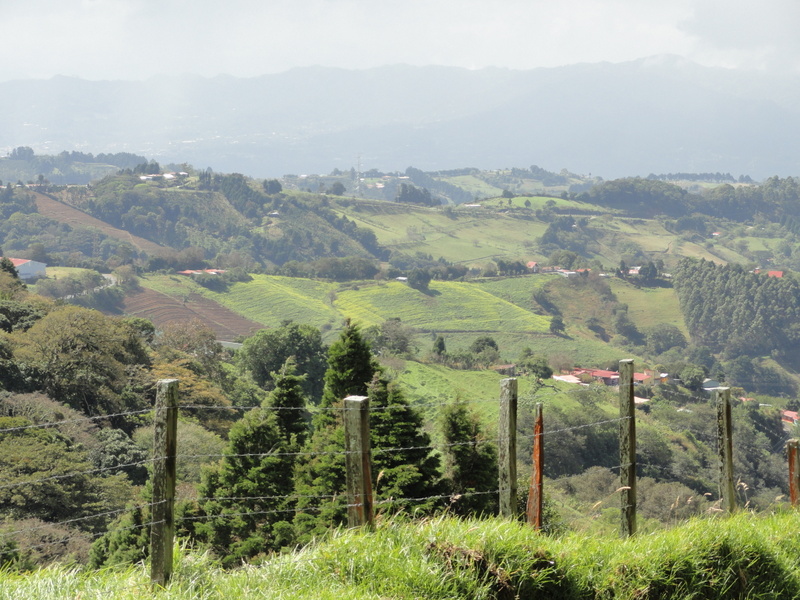
This is the view from in front of our house. This ride starts at the school in La Palmita. Head south down to the highway and turn right to Zarcero.

Here's some of the famous topiary in the park.

The church has recently been restored and the inside is well worth a visit. Turn right just past the church and start climbing.

The road is narrow, but the traffic is light and slow,

It started raining when I was about half-way to Palmira. The rules clearly state that when it the rainfall is not hard enough to put out your cigarette, you must continue.


Main street. Palmira at rush hour. Turn around here. If you have been thinking of continuing on to see the waterfall that is in Bajo del Toro, be advised that there are 10 Km of very steep, narrow, mostly unpaved roads ahead of you.
You have earned a great downhill run back to Zarcero.


Turn left at the park. You may want to get a coffee and spend some time in the park before continuing back to La Palmita. You can get coffee just about anywhere, but Osman's Market across from the park also has expresso drinks.
Here's a link to the map, route slip, and elevation profile.
Saturday, November 17, 2012
My First Post. La Palmita - San Ramon Loop
Well, here it goes. I'm joining the ranks of bloggers, something I never saw myself doing. I'm still figuring out how to format and use it but, it's time to get started with the posts.
My intention is identify and document bicycle routes in Costa Rica and create a searchable database of them. To do so, I will be using bikely.com. I have used this site in the U.S, and it's a great way to share bike routes. All of my route names will have the prefix of "OKG" for Old Krank Gringo, so the full list can be accessed with an advanced search of bikely.
Anyone who lives or travels in Costa Rica knows that addresses and directions here are a challenge. Many maps lack details of the smaller roads that are less traveled and therefore more suited to bicycles. You also don't find many signs that identify the route number that you find on a map. Directions are often given as, "Turn right 200 meters past where the big tree used to be (except in Spanish)." All the locals understand, but it doesn't help us much.
I'll add a narrative here along with photos and landmarks to help along the way. I'll try to pick landmarks that will be around for a while. You will have to exercise your own judgment regarding the safety and difficulty of each route.
http://www.bikely.com/maps/bike-path/la-palmita-san-ramon-loop
I have done this loop 3 or 4 times and it's very scenic and mostly low traffic. It's not very long, but it requires 4400 ft of climbing. Because of that I frequently just ride an out and back ride of the last 15 miles of this route. If you like to climb, this is good one for you.
The ride starts in La Palmita because that is where we live. There is safe free parking near the school. All of the route is paved and is in reasonably good condition.

Start by heading south down to the main highway.

Turn left onto HWY 35. You won't find any sign here. You will be going mostly downhill, with a few short climbs. This is presently a main route from Naranjo to San Carlos. So expect auto, moto, truck, and bus traffic. Sunday mornings have less commercial traffic. The many curves in the road help to slow the vehicles.


Pass El Mirador restaurant and take the first right you find. There is a bus stop at the intersection. You will see this sign after the turn.
You will now be on a very low traffic road. The next part of the ride runs along a ridge with great views on each side and then starts a rapid descent. It's very difficult to do justice to the panoramic views with a photo, but here are some landmarks along the route.


Turn left at this Tee in the road.


The first serious climb starts after this bridge. It's steep but not too long.

This is on your right just before your next turn.

Turn right at the bar. There will be a little more traffic here, but it's not too bad. It's also mostly slow moving.
Now it's time to pay for all of the great downhill riding. The next section of the road will be mostly climbing. It starts will some rolling hills and gets more serious after you pass through Volio. After a narrow bridge, there is a 1.5 Km steep climb followed by some more rolling hills. Then more climbing as you pass San Antonio and enter Barranca. A short stretch of flat road leads to the final climb on this road.
The road ends in a Tee, where you turn left.


Almost done!

Turn right and return to the school. You did it!
My intention is identify and document bicycle routes in Costa Rica and create a searchable database of them. To do so, I will be using bikely.com. I have used this site in the U.S, and it's a great way to share bike routes. All of my route names will have the prefix of "OKG" for Old Krank Gringo, so the full list can be accessed with an advanced search of bikely.
Anyone who lives or travels in Costa Rica knows that addresses and directions here are a challenge. Many maps lack details of the smaller roads that are less traveled and therefore more suited to bicycles. You also don't find many signs that identify the route number that you find on a map. Directions are often given as, "Turn right 200 meters past where the big tree used to be (except in Spanish)." All the locals understand, but it doesn't help us much.
I'll add a narrative here along with photos and landmarks to help along the way. I'll try to pick landmarks that will be around for a while. You will have to exercise your own judgment regarding the safety and difficulty of each route.
http://www.bikely.com/maps/bike-path/la-palmita-san-ramon-loop
La Palmita - San Ramon Loop
The ride starts in La Palmita because that is where we live. There is safe free parking near the school. All of the route is paved and is in reasonably good condition.
Start by heading south down to the main highway.
Turn left onto HWY 35. You won't find any sign here. You will be going mostly downhill, with a few short climbs. This is presently a main route from Naranjo to San Carlos. So expect auto, moto, truck, and bus traffic. Sunday mornings have less commercial traffic. The many curves in the road help to slow the vehicles.
Pass El Mirador restaurant and take the first right you find. There is a bus stop at the intersection. You will see this sign after the turn.
You will now be on a very low traffic road. The next part of the ride runs along a ridge with great views on each side and then starts a rapid descent. It's very difficult to do justice to the panoramic views with a photo, but here are some landmarks along the route.
Turn left at this Tee in the road.
The first serious climb starts after this bridge. It's steep but not too long.
This is on your right just before your next turn.
Turn right at the bar. There will be a little more traffic here, but it's not too bad. It's also mostly slow moving.
Now it's time to pay for all of the great downhill riding. The next section of the road will be mostly climbing. It starts will some rolling hills and gets more serious after you pass through Volio. After a narrow bridge, there is a 1.5 Km steep climb followed by some more rolling hills. Then more climbing as you pass San Antonio and enter Barranca. A short stretch of flat road leads to the final climb on this road.
The road ends in a Tee, where you turn left.
Almost done!
Turn right and return to the school. You did it!
Subscribe to:
Posts (Atom)